Suunto Vertical 2 User Guide
Points of interest
A point of interest, or POI, is a special location, such as camping spot or vista along a trail, you can save and navigate to later. You can create POIs in Suunto app from a map and do not have to be at the POI location. Creating a POI in your watch is done by saving your current location.
Each POI is defined by:
- POI name
- POI type
- Date and time created
- Latitude
- Longitude
- Elevation
You can store up to 250 POIs in your watch.
Adding and deleting POIs
You can add a POI to your watch either with Suunto app or by saving your current location in the watch.
If you are outside with your watch and come across a spot you want to save as a POI, you can add the location directly in your watch.
To add a POI with your watch:
- Swipe up or press the lower button and select Map.
- Press the lower button to open Navigation options.
- Select Your location and press the middle button.
- Wait for the watch to activate GPS and find your location.
- When the watch displays your latitude and longitude, press the upper button to save your location as a POI and select the POI type.
- By default the POI name is the same as the POI type (with a running number after it). You can edit the name later in Suunto app.
Deleting POIs
You can remove a POI by deleting the POI from the POI list in the watch or removing it in Suunto app.
To delete a POI in your watch:
- Swipe up or press the lower button and select Map.
- Press the lower button to open Navigation options.
- Select POIs and press the middle button.
- Scroll to the POI you want to remove from the watch and press the middle button.
- Scroll to the end of the details and select Delete.
When you delete a POI from your watch, the POI is not permanently deleted.
To permanently delete a POI, you need to delete the POI in Suunto app.
Navigating to a POI
You can navigate to any POI that is in your watch POI list.
When navigating to a POI, your watch uses full power GPS.
To navigate to a POI:
- Swipe up or press the lower button and select Map.
- Press the lower button to open Navigation options.
- Select POIs and press the middle button.
- Scroll to the POI you want to navigate to and press the middle button.
- Press the upper button or tap Select.
Select Start exercise if you want to use the POI for exercising or select Navigate only if you only want to navigate to the POI.
NOTE:If you only navigate to the POI, nothing will be saved or logged in Suunto app.
If you only navigate the route, press the lower button and select End navigation to stop navigating. If you navigate during an exercise, press the lower button and select Breadcrumb to stop navigating without quitting the exercise.
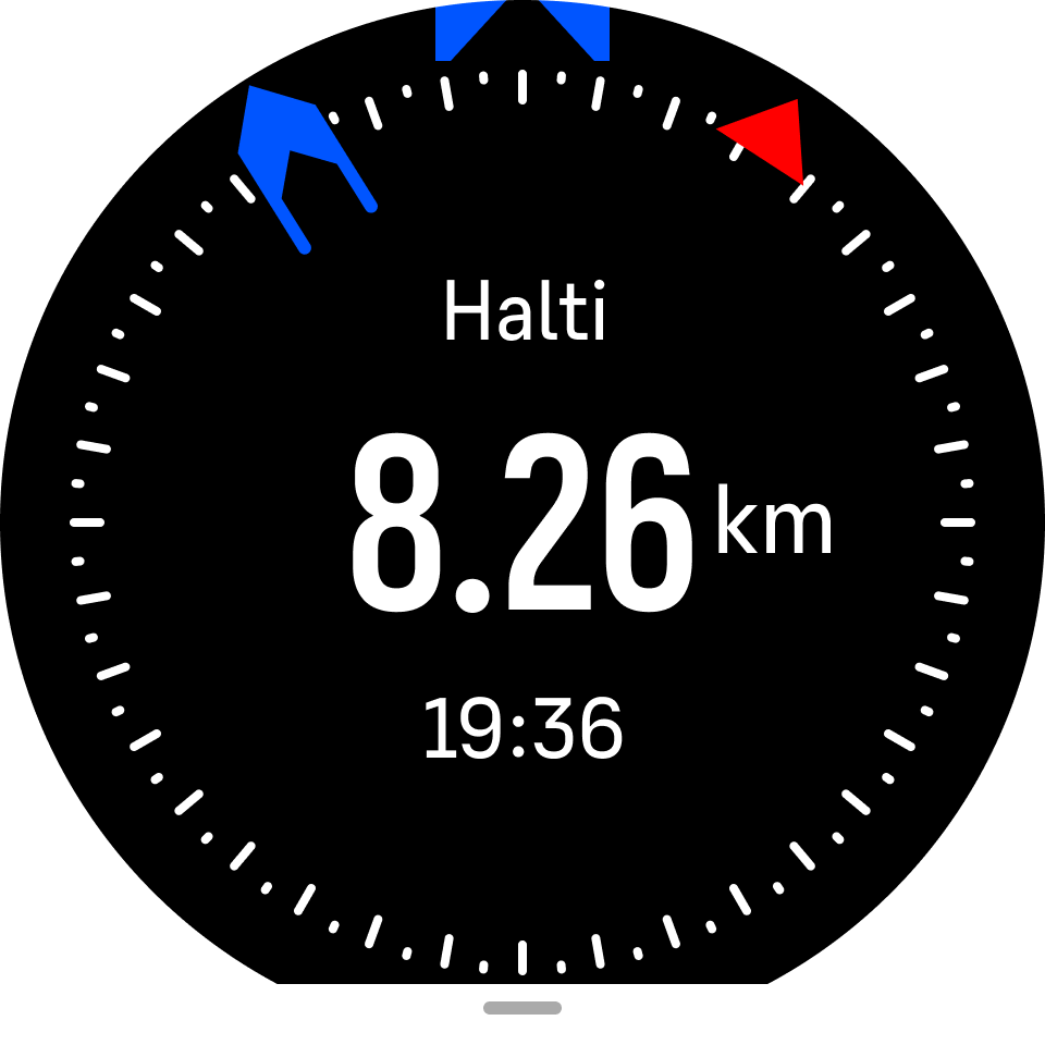
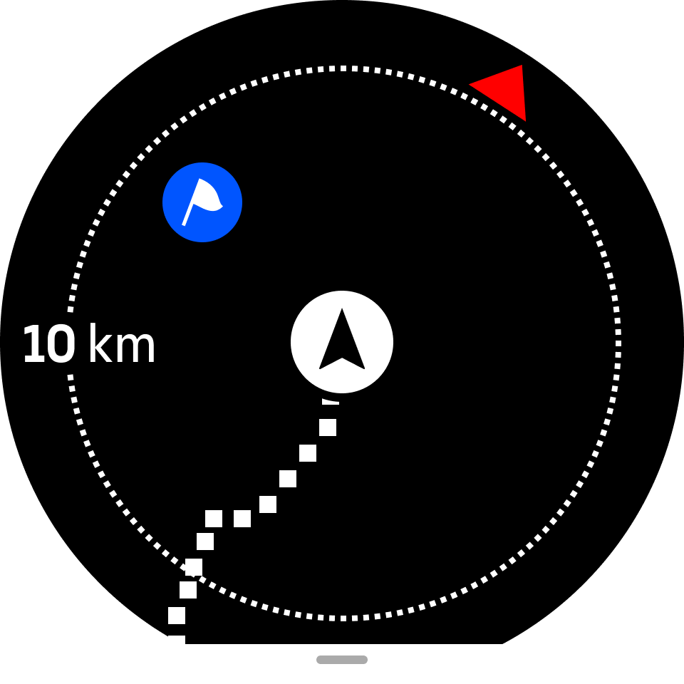
The POI navigation has two views:
POI view with direction indicator and distance to the POI
map view showing your current location relative to the POI and your breadcrumb trail (the track you have traveled)
Press the middle button, to switch between views.
NOTE:If offline maps are activated the map view will display a detailed map of your surroundings.
In the map view, other POIs nearby are shown in gray. In the map view, you can adjust the zoom level by pressing the middle button and then zooming in and out with the upper and lower buttons.
While in the POI view, tap on the screen to see additional information in the lower row such as altitude difference between current position and POI and estimated time of arrival (ETA) or en route (ETE).
While navigating, you can press the lower button to open a list of shortcuts. The shortcuts give you quick access to POI details and actions such as saving your current location or selecting another POI to navigate to, as well as ending navigation.
POI types
The following POI types are available in Suunto Vertical 2:
| Begin | |
| End | |
| Car | |
| Parking | |
| Home | |
| Building | |
| Hotel | |
| Hostel | |
| Lodging | |
| Bedding | |
| Camp | |
| Camping site | |
| Camp fire | |
| Aid station | |
| Emergency | |
| Waterpoint | |
| Information | |
| Restaurant | |
| Food | |
| Cafe | |
| Cave | |
| Mountain | |
| Peak | |
| Rock | |
| Cliff | |
| Avalanche | |
| Valley | |
| Hill | |
| Road | |
| Trail | |
| River | |
| Water | |
| Waterfall | |
| Coast | |
| Lake | |
| Kelp forest | |
| Marine reserve | |
| Coral reef | |
| Big fish | |
| Marine mammal | |
| Wreck | |
| Fishing spot | |
| Beach | |
| Forest | |
| Meadow | |
| Coast | |
| Stand | |
| Shot | |
| Rub | |
| Scrape | |
| Big game | |
| Small game | |
| Bird | |
| Prints | |
| Crossroads | |
| Danger | |
| Geocache | |
| Sight | |
| Trailcam |