Suunto Traverse Uporabniški priročnik - 2.1
Poti
Pot lahko ustvarite v storitvi Movescount ali uvozite pot, ustvarjeno v drugi storitvi.
Kako dodati pot:
- Obiščite storitev www.movescount.com in se prijavite.
- Uro Suunto Traverse sinhronizirajte s storitvijo Movescount z uporabo Suuntolink in priloženega kabla USB.
V storitvi Movescount je poti mogoče tudi izbrisati.
Navigating a route
You can navigate a route you have transferred to your Suunto Traverse from Movescount (see 3.20 Routes) or from a log in your logbook with GPS data. You get a preview of the route based on the route list or logbook selection.
If you are using the compass for the first time, you need to calibrate it (see Calibrating compass). After activating the compass, the watch will begin searching for a GPS signal. After the watch acquires a GPS signal, you can begin to navigate a route.
To navigate a route:
- Press to enter the start menu.
- Scroll to NAVIGATION with and press .
- Scroll to Routes or NAVIGATION and press to enter .
- Scroll to the route you want to navigate with or and press .
- Press to select Navigate. All navigating is recorded. If you watch has more than one sport mode, you are prompted to select one.
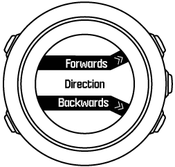
- Select Forwards or Backwards to chose the direction you want to navigate (from the first waypoint or the last).

- Start navigating. The watch informs you when you are approaching the beginning of the route.

- The watch informs you when you have arrived at your destination.
You can also start navigating while recording an activity (see Recording activities).
Med navigacijo
Med navigacijo pritisnite tipko , da se premaknete na naslednje prikaze:
- prikaz cele proge, ki prikazuje celo pot
- povečan prikaz poti: povečan prikaz privzeto uporablja merilo 100 m (0,1 milje) oziroma večje merilo, če ste daleč od poti
Prikaz proge
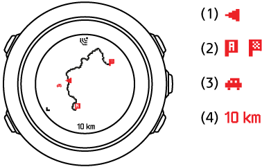
Pogled cele proge prikazuje naslednje informacije:
- (1) puščica, ki označuje vašo lokacijo in kaže v smer, kamor ste namenjeni;
- (2) prva in zadnja točka na poti;
- (3) najbližja zanimiva točka je prikazana kot ikona;
- (4) merilo, uporabljeno za prikaz proge.

V prikazu cele proge je sever vedno zgoraj.
Orientacija zemljevida
Orientacijo zemljevida lahko spremenite v meniju z možnostmi NAVIGATION (NAVIGACIJA) » Settings (Nastavitve) » Map (Zemljevid) » Orientation (Orientacija).
- Heading up (Smer gibanja zgoraj): Prikazuje povečani zemljevid tako, da se gibate v smeri navzgor.
- North up (Sever zgoraj): Prikazuje povečani zemljevid tako, da je sever zgoraj.
Pogled profila vzpona
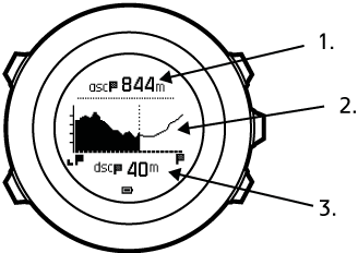
Pogled profila vzpona prikazuje naslednje informacije:
- preostali vzpon;
- diagram profila nadmorske višine v realnem času;
- preostali spust.

Če se preveč odmaknete od začrtane poti, se grafikon profila ne posodablja. Namesto tega se pod grafikonom prikaže napis Off route (S poti). Za natančen izračun vzpona se vrnite na začrtano pot.